The small gulf of Sigacik on the shore of the peninsula south of Izmir was described by the famous 16th century Turkish navigator and cartographer Piri Reis as "an anchorage with water like yufka", in other words waters as soft and calm as the paper thin pastry, "yufka". Ancient seafarers discovered this hospitable shelter from storms 3000 years ago.
Sigacik lies between the headlands of Doganbey Burnu and Teke Burnu. Its shores have been home to many of the peoples who made their home in Asia Minor, bringing their rich array of cultures, and the inhabitants of this region were aptly described by the ancient Egyptians as "the people who live in the heart of the sea". Today Sigacik is a magnet for windsurfers, sailors with its modern marina and, less predictably, rock climbers attracted by the challenge of towering cliffs on a small island.
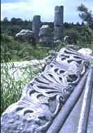
Teos was founded in 1050-1000 BC, one of twelve Ionian cities. In this beautiful part of the Aegean coast the people of Teos built magnificent architectural monuments, such as the Temple of Dionysus which stands at the edge of the road. The temple was built at the beginning of the 2nd century BC by Hermogenes of Priene and is the largest of all temples to Dionysus in Turkey. It was repaired several times during Roman times but several earthquakes took their toll. Walking along the paved road of Teos your eye is caught by a column capital here, and a water conduit there.
 Five hundred meters to the northwest you can discover Hellenistic walls, a theater, acropolis and gymnasium. Inscriptions found here reveal that the gymnasium had three classes and three teachers, two for sport and one for music. Looking south from the gymnasium you see a tiny jetty with rowing boats. This is the remains of the ancient breakwater of the South Harbor. Beyond is a tiny island known variously to local people as Cifitkale, Cifte Kale or Korsan Adasi today, but in the 16th century it was called Cüneyd Kalesi by Piri Reis. Another alternative is the ancient Myonnessos. To reach this island, so generously blessed with names for such a small place, you must return along the road to Seferihisar and head south.
Hekataios of Miletus described Myonnessos as a town in the 6th century BC and it is thought to have subsequently become a pirate stronghold (recalled in the name Korsan Adasi, Pirates Island). The only remains from the archaic period is a 5-6 meters piece of wall on the northwest side. The other ruins and cisterns date from Seljuk and Ottoman times. The names Cifitkale or Cifte Kale (kale meaning fort or castle in Turkish) refer to the time when the last ruler of the Turkish Aydinogullari Principality Cüneyd Bey made his last stand in his fort here before being defeated by the Ottoman sultan Murad II (1421-1451).
To see the island at closer quarters you do not need to take a boat, but can walk along the 80 meter long ancient submerged pier lying 25-30 centimeters beneath the surface of the water. This is the way used by mountaineers who come to climb the towering 62 meter high rock cliffs on the south side of the island.
Just as Sigacik Bay is a calm refuge for storm battered sailors, so Cifitkale attracts climbers and those wishing to enjoy the delights of clear blue sea and superb scenery. There are many small restaurants in Sigacik harbor where you can taste traditional Turkish cuisine and local fish accompanied by glasses of ice-cold cloud white raki.
On 30th of October 2020, a strong earthquake in the Aegean Sea off Seferihisar coast hit the surroundings, killing many people in Izmir city, but especially causing a tsunami in Sigacik town.

